Five-Day Backpacking Trip, Gallatin Divide Trail, Gallatin
National Forest, Montana
Text by Mark Sheehan, Photos by Jan Mack
Between August 20 and 24, 1997 Jan Mack and I took five Boy Scouts on
a five-day, 50-mile backpacking trip from Hyalite Creek Trailhead (15
miles south of my house) to the Daly Creek trailhead in the extreme
northwest corner of Yellowstone National Park. The scouts were Tyler
Mack, Peter and Christopher Hancock, Justin Leishman, and Nathan
Ziegler, all of Troop 679, Mountain Valley District, Montana Council,
BSA. Most of the way we followed the "Gallatin Divide Trail" which is
a continuous, but at times obscure, path along the crest of the
Gallatin Range. The first day was a 5.5 mile climb to Hyalite Lake, at
the base of Hyalite Peak. (Hyalite is a mineral - a cousin to the opal
that in fact has some small local value as a curiosity and is found in
this area. It isn't a gemstone, but looks like dribbles of clear glass
on black or gray or red volcanic rock.) The lake is a 'tarn' -- one of
those glacial features found at the heads of the U-shaped valleys that
glaciers carve. It's shallow enough that it doesn't support a fish
population, though several other nearby lakes (in other U-shaped
valleys) do.
|
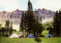
We arrived at Hyalite Lake at about 1pm, set up camp, had lunch,
and then went prospecting for opals for the rest of the afternoon. The
kids loved it. We had some success. They stashed their finds near the
lake so they could return and retrieve them on another trip. Our packs
ranged from 40 to over 50 pounds (mine was 49 at the outset) and we
didn't need to add to the load with rocks.
|
| Our Camp At Hyalite Lake
|
|
Sadly, my son David wasn't among the campers. He and I had climbed
Hyalite Peak the Sunday before the backpacking trip and on the way
down he'd slipped at a stream crossing and had fallen on his wrist,
pulling the cap of a bone away from the cartilaginous growth area
below it. So he elected to stay behind. That meant I slept alone,
which was fine, except that I had to carry 100% of what I needed
rather than the expected 50% of tent, cook kit, and other sharable
resources.
It clouded up Wednesday night, so while we were sleeping at Hyalite
Lake we had thunder and lightning. It's an amazing phenomenon at such
elevations and in a glacial cirque! We felt we were right at the
center of each thunderclap, and the nearby lightning was unbelievably
intense. The storm didn't last long, there wasn't too much rain,
and by morning the sky was clear again. From then on, with the
briefest exception Sunday morning, our weather was great.
|
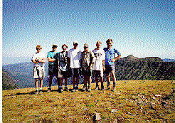
The second day we climbed Hyalite Peak, I phoned home from the
summit on my cell phone to reassure any potentially nervous parents,
and then made our way out along the high ridge that extends south from
the peak. The lake had been at about 9,000 feet and the peak was at
about 10,300 feet. The ridges stayed in the vicinity of 9,500 feet
throughout most of the trip. We hiked across grassy tundra, sometimes
miles of it, stretching out on either side for half a mile or more,
right up to the verges of cliffs and canyons. Sometimes we went
through woods of limber pine and spruce clinging to the crests of
narrow ridges.
| 
|
|
| The Crew on Hyalite Peak
|
Other times we dipped down into the spruce-fir forests
that blanketed the canyonsides. Always to our left were the Paradise
Valley, then the volcanic crags of the Absaroka range (ab-SAIR-uh-kuh:
'people of the crow' in the Crow Indian language) and to our right
were the Gallatin River valley, the Spanish Peaks of the Madison
Range, and then later Lone Mountain (location of Big Sky ski resort)
and The Sphinx in the Madisons. Ahead of us, often visible, was
Electric Peak near Gardiner. It's a magnificent mountain (and because
of its name, it made me mindful of Electric
Pass Peak in Colorado and my run-in there with the crow).
|
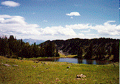
Lunch Thursday was at Crater Lake, a small, but beautiful little
pond tucked into a diminutive valley right at the crest of the
Gallatins. From there we entered a "vortex of confusion." We had maps
dated 1955 and 1989. The trail south of Crater Lake was shown on the
two maps in two different positions and we could find it in neither of
them. So we bushwhacked about a mile and a half, which nearly exhausted
us all several times over, took three hours, and left us very low on
drinking water.
|
| Crater Lake on the Gallatin Divide
|
|
We could see the switchbacks of the trail ahead of us
as it ascended a 500 feet rise in the ridge, but we couldn't find a trail
that would get us to them. We set our sights on the lowest switchback
and headed straight for it. When we got there we found the trail
suddenly began and was well defined, but to the north of that point,
in the direction we'd come from, there was not the least sign of a
trail of any sort. Fortunately we found a snowbank and were able to
make ourselves some drinking water out of it.
We climbed the switchbacks in a state of exhaustion. At the top the
view was spectacular and refreshed us a little. It was clear we
wouldn't get as far as we'd hoped by nightfall, but in the distance we
spotted a safe-looking campsite down off the tundra, away from any
rocky promontories, nestled among the limber pines. We steered for
that, found another good snowbank along the trail, pumped about eight
liters of water from its runoff (pumped it through our backpackers'
water filters), and made it to our (very nice!) campsite well before
dark.
Our dinners tended to be "Pasta-Roni" kinds of things, usually with
a can of chicken or tuna mixed in. That's pretty much a meal for two
people. I'd planned meals intending to share with son David; when he
bailed out I could cut back on everything but the dinner entrees. It's
hard to divide a can of tuna in two, or a Pasta-Roni seasoning packet,
so I was able to share my dinners each night with scouts whose
stomachs still had empty corners. Lipton also makes some good dinners,
by the way. A few of the kids brought expensive "backpacker's meals"
but generally found them either unpalatable, unsatisfying, or too
complicated to prepare. Thursday night's "Lemon and Herb" Angel Hair
Pasta-Roni with tuna was delicious.
All Thursday night I slept fitfully. I kept hearing elk "coughing"
in the timber all around. Tuesday night I'd slept poorly because of
anxiety about the upcoming trip. Wednesday the lightning kept me
up. So Thursday was my third night in a row of poor sleep.
Friday we had good, clear trails, plenty of snow to melt for water,
and at least 14 miles ahead of us to get to Golden Trout Lakes. There
we were going to be met by a small group of parents, scout leaders,
and other scouts who were considering joining us for the last two
days. They brought in some fruit and dessert and some soda pop that
the kids had requested via cell phone during our Thursday check-in
call. ...But that gets me ahead of the story of Friday. Nearly our
whole day Friday was spent on the USGS map called "The Sentinel." On
the entire map there are only a few miles of dirt road. The rest of it
is basically wilderness, though its status is National Forest (I've
learned recently that part of the Gallatin National Forest in this
area is now a wilderness study area, which may afford it some
protection or at least special consideration when land use questions
arise); near the road there are a number of clear-cut areas, but most
of the rest of it looks untouched. We had lunch overlooking the cirque
in which Bark Cabin Creek heads. It was fabulously beautiful. The
valley bottom was grassy, dotted with trees, and we expected to see
herds of elk grazing, being stalked by grizzlies. In fact, we saw no
wildlife at all, but the area was still enchanting. The mountain named
The Sentinel was just over our right shoulders as we lunched; if we'd
had more time we could easily have ambled up the grass to its summit.
We pressed on to Windy Pass, meandered around the huge,
miles-square tundra area atop the pass, eventually found our way to
the Eaglehead Peak trail after adding two confused miles to our total
(16 miles for the day). Soon we began our climb of the peak. To get to
Golden Trout Lakes we had to leave the trail somewhere along the
mountain ridge. Our options were either to go up a shoulder of the
peak and drop over into the cirque, bushwhacking our way to the
largest of the three lakes; or to go to the summit and drop down 1000
feet directly to the lake. Jan had done the latter on a previous trip,
but after 14-15 miles of hiking none of us relished the idea of
climbing to the summit just to descend again. We decided to try the
shoulder approach. It involved lowering ourselves into a gully on the
side of the mountain and inching down to the base of the cirque. It
was a slow, dangerous business and consumed two hours of our time. We
got everyone down, across some frighteningly steep grassy slopes, over
a lot of very loose rock, and onto the cirque floor. On the way we
passed over a remarkable deposit of petrified wood. There were stone
treetrunks still rooted to the slope, snapped off at ground level and
showing years and years of growth rings. Everywhere there were shards
of wood, looking natural but clinking like the stone that they
actually were. There was petrified cordwood all around -- quarters of
logs, 16-24 inches long, made of stone. There were roots and stems and
bark, all mineralized in fabulous shades of cream, tan, brown, yellow,
and red. We literally couldn't believe what we were seeing. (The
Eaglehead Peak area is within the protected Gallatin Petrified
Forest. A [free!] permit is required to collect specimens there.)
|
Once in the cirque it took us 30-40 minutes to find our lake. We
greeted our friends and families there. My son Mike and another Scout
named Brandon Rogers had hiked in. Mike's intent was to share my tent
and then hike out the next morning with Dick Lund and Jarvis Brown,
the district leaders who had hiked in with the parents to see how we
were doing and to stay the night. Brandon slept alone. He and Mike
were invited to do a day hike back up to the ridge with us the next
day and then go back home Saturday morning with Mike, Dick, and
Jarvis. We had dinner, the parents left, and for the first time on the
hike I slept well.
| 
|
|
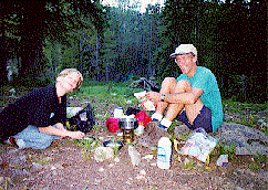
| Father and Son Cooking at Golden Trout Lakes
|
Saturday morning, Mike, Brandon, Dick, and Jarvis followed (and at
some points led) us up onto Eaglehead Peak and sent us on our way
after feeding us fresh cantaloupe. We found more petrified wood on the
summit and as we walked out across the tundra also found some Indian
artifacts made out of the stuff. I found a perfect little hide
scraper, made for a hand smaller than mine, discarded, I assume,
because it had gotten a chip in it. As I held it I tried to imagine
how it had felt in the hand of its original owner. I was immediately
overcome by a feeling that it was wrong for me to remove it from the
mountain, so I tried to throw it -- like a skipping stone -- off to my
left. Somehow, though I've skipped a thousand stones in my day, I
couldn't release the stone when I wanted to, and I wound up throwing
it all the way around my back and off to the right of the trail -- the
side I had found it on. It seemed very weird at the time, as though
the hand I held it in were no longer my own. Spooky....
We found the trail hard to follow south of Eaglehead. It led us
through craggy ridgetop rocks and across wide areas of grass and
boulders where there were head-sized chunks of opaque white
quartz. All along the way there were chips and flakes of rock that
clearly showed signs of human industry. We felt like we were walking
through hundreds of years of Indian encampments. It's a place I want
to revisit.
The trail became clearer in a mile or two, a narrow red track
following the very crest of the mountain range. At many places our
footsteps fell exactly on the divide between the Yellowstone River to
the left and the Gallatin to the right.
After passing through a delightful, grassy woods of limber pine
(and making LOTS of noise to let the grizzlies know we were coming),
we descended into a saddle, then were faced immediately by the
longest, steepest climb of the trip, up to the shoulders of Fortress
Mountain. At the high point of the trail, coming our direction from
Ramshorn Lake, two horses and two women riders suddenly appeared. Five
of us, completely out of breath, had stopped there to rest. We spoke
softly to the horses so as not to spook them on the narrow trail. The
riders started down the other side, down the steep trail we'd just
come up, when the remaining two scouts emerged from the trees. The
horses freaked out! They reared and bucked and nearly threw their
riders. They left the trail and staggered on the steep, uneven
slopes. I was sure they were going to tumble. But as it happened, they
regained their footing and headed back up the trail toward us. The
riders dismounted and led the horses behind them. Meanwhile, our last
two scouts had left the trail and headed toward us along the
ridgecrest, through the brush and small trees.
We spoke to the riders for a while, apologized, and found out where
things had gone wrong. One of the horses was just a colt and had never
seen humans with backpacks before. It simply panicked. We were very
relieved that no one was hurt.
In hopes of finding something to drink, we'd been steering toward a
patch of snow. The steep trail had bypassed it, though, so we were
concerned about where we might stop for lunch. On our maps we located
a small pond a mile or so below the shoulder of the mountain, along
the trail. We continued toward it, passing the impressive western
ramparts of Fortress Mountain on the way, filtered some water from the
pond, rested, and lunched.
Within an hour after lunch we arrived at Ramshorn Lake. It's a deep
blue jewel of a lake at the base of some rugged white volcanic
cliffs. A beautiful spot. We had thought we might go farther that day
-- our fourth -- but after doing 16 miles the day before we were
exhausted enough to want some rest. We found a pretty campsite back in
the forest and spent the afternoon swimming, sunning, sewing, and
maintaining some of our gear. (Jan's water filter had clogged and
needed work. My pack had been damaged by the sheath of the pocket
knife hanging from my belt, and needed to be sewn up.)
We rested well, fixed warm, satisfying suppers, had a nice
campfire, and went to bed feeling at peace. I slept VERY well, and
even dreamt a little.
Sunday morning at 6am my alarm went off, though I was half-awake
already. Not 20 seconds later, it began to rain. Fortunately the
shower lasted only long enough to wet our tents' rainflies and didn't
interfere with breakfast or with breaking camp. We walked down the
Ramshorn Lake trail to Buffalo Horn Creek, a very heavily overused
trail. (There had been several parties of day-hikers at Ramshorn Lake,
and a number of tenters. It was the only "competition" we'd had for
tent sites the entire trip.)
|
We turned south from the Buffalo Horn Creek trail onto the Tepee
Pass trail, and hiked up past a grizzly-clawed ranger station (where
we got water from a spring) to the pass. All the way down from the
pass along Tepee creek, across the divide to Daly Creek, and on to the
trailhead, we walked through tall grass and sage. It was very
different country from the tundra of the first four days. We ran into
a group of eight motorcyclists on the Tepee Creek trail, missed a turn
and wound up farther south on Tepee Creek than we'd hoped. We
backtracked a little after lunch, and finally crossed the boundary of
the National Park with a chorus of yelps and hurrahs.
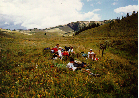
|
| Lunch stop along Teepee Creek
|
|
The hike down Daly Creek was long and rough until we hit the
trail. From there it was just long.... We hit the trailhead at 2:48pm,
12 minutes before we'd predicted we would. At that exact moment one of
our shuttle drivers (Kris Hancock) arrived to pick us up. She passed
out sodas and snacks and we debriefed a little. Kathy, my wife, and
Justin's mother Marian arrived a few minutes later with a cheesecake
and another round of sodas. After gratefully consuming all those
calories we squeezed into the two vehicles and headed back to Bozeman.
That was the longest backpacking trip I've ever taken, both in
terms of days and of distance. For all the scouts except Tyler, it was
the first backpacking experience they'd had. We completed
the major requirement for the Scout 50-Miler Award, fulfilled a big
requirement for the Backpacking Merit Badge, and got several Scouts a
lot closer to both the Camping and Hiking Merit Badges. We all had a
good time and learned a lot. The next evening at our regular Scout
meeting all the boys who had been on the trip said loudly that they
would eagerly do it again. ...Sounds like success to me!!
Constructed and maintained by
Mark Sheehan
Hop to my Tripod Trip Report Web site
Hop to
my Montana
State Web site